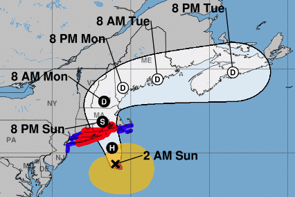
Long Island stands in the crosshairs of a hurricane that could potentially wreak havoc with flooding, power losses, downed trees and all the misery that comes with that.
Hurricane Henri, packing hard rains and winds of 75 mph or more, was projected to begin hitting Saturday night and make landfall Sunday afternoon on Long Island or in southern New England. The Category 1 storm, which trended east slightly as of 7:50 p.m. Saturday, is expected to bring several inches of rain across the Northeast, and some areas may see storm surges of up to 5 feet, forecasters said.
The hurricane would be the first of its kind to directly strike Long Island since Hurricane Gloria in 1985.
PSEG Long Island has almost doubled its estimate of how long some residents may be without power, saying outages now could last up to two weeks.
Much depends on how fast the storm moves and where it lands, experts say. The National Hurricane Center said various computer models do not agree on the storm's track, but the models generally focused on central Long Island and Rhode Island.
"The animation loop shows a little bit of an eastward slide in the track ... which is good for Long Island; the farther east the storm goes, the less will be the impact here," said meteorologist Bill Korbel on Saturday evening.


No comments:
Post a Comment
Note: Only a member of this blog may post a comment.